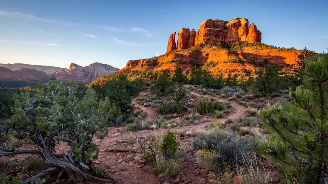
Sedona does something to first-time visitors that few places in America can manage. You round a bend on Highway 179 and a skyline of red rock — spires, buttes, and fins in impossible shades of rust and ember — just stands there glowing. Then you lace up your boots and realize the real Sedona is not the drive-by view. It is the trails: hundreds of miles threading through sandstone canyons, climbing to natural arches, and wandering creek-fed groves of sycamore and cottonwood. The trick is matching the route to your day, your legs, and your appetite for crowds.
This guide covers eleven standout trails, from easy sunset walks to a strenuous summit climb — with honest distances, difficulty notes, and the logistics that separate a great Sedona day from a frustrating one.
Before You Hit the Trail: Sedona Hiking Essentials
Many trailheads in the Coconino National Forest are designated fee sites, which means you need a Red Rock Pass — about $5 per day or $15 per week — or a qualifying federal pass. Buy it online, at local retailers, or from trailhead machines before you park.
The free Sedona Shuttle serves the busiest trailheads — Cathedral Rock, Soldier Pass, and the Dry Creek Vista area near Devil’s Bridge. On peak days, driving straight there is a gamble; check the current shuttle schedule before you plan around it. If you are hiking with kids, seniors, or a mixed group, our roundup of America’s best hiking trails for every skill level offers more graded options across the country.
Season matters. Spring and fall bring the most comfortable hiking weather, with highs in the 60s to low 80s. Summer tops 100 degrees and brings monsoon storms that can flood desert washes in minutes — never enter a narrow canyon when thunderheads are building. Winter brings cold mornings, thin crowds, and occasional snow dusting the red rock. At 4,350 feet, the sun is stronger than you expect; sunscreen, a hat, and at least two liters of water per person for hikes over two miles are non-negotiable.
1. Cathedral Rock: The Iconic Scramble
Cathedral Rock is Sedona’s signature hike: a 1.1- to 1.5-mile out-and-back climb that trades distance for steepness, gaining nearly 700 feet through rock steps and polished-slab scrambles to a saddle with cathedral-like views down Oak Creek. It is strenuous in short bursts, and slick rock can be treacherous when wet — skip it after rain.
Parking is the crux: the lot is small, and the shuttle has replaced direct parking on many days. Arrive before 8 a.m. or take the shuttle. Sunset is the magic hour here — and the busiest. The slick rock is treacherous when wet, and the exposed scramble rewards the same caution our guide to staying safe on adventure trips recommends: tell someone your plan, carry more water than you need, and turn back before trouble finds you.
2. Devil’s Bridge: The Famous Natural Arch
Devil’s Bridge is the largest natural sandstone arch in the Sedona area, and the payoff — standing on a narrow arch with red rock canyons dropping away on both sides — explains why its trailhead fills before 9 a.m. on weekends. The route runs about 4.2 miles round trip from the Dry Creek Vista trailhead, moderate in difficulty, with a short but exposed final scramble up to the arch itself.
A rough forest road shortens the walk for high-clearance vehicles; otherwise, plan on the full distance. Expect a line for the iconic arch photo — weekends can mean a 30-minute wait, so early weekday mornings are the sweet spot. The exposure is real but manageable; keep children close at the summit ledge.
3. West Fork of Oak Creek: The Shaded Canyon Walk
West Fork is routinely ranked among the best hikes in Sedona, and it is unlike the rest of this list. Instead of exposed red rock, you walk a gentle 6.5-mile out-and-back up a lush canyon where Oak Creek crosses the trail a dozen times and sheer walls close in to a few dozen feet wide. Fall turns the canyon into a tunnel of gold — plan a fall trip and you will understand why photographers rank this among the top ten trails in America.
The catch: the small parking lot fills fast, and storm damage can change trail status — check Coconino National Forest conditions before driving out. Waterproof footwear helps at the creek crossings. This easy-to-moderate walk suits almost any group, making it the perfect first or last hike of a trip.
4. Bell Rock and Courthouse Butte Loop
Bell Rock is the most visible formation in the Village of Oak Creek, and its surrounding trail system is the friendliest introduction to Sedona hiking. The full loop around Bell Rock and Courthouse Butte runs about 3.9 miles on well-marked trail, rated easy to moderate, with options to climb Bell Rock’s lower slopes for views if you are feeling adventurous. One of Sedona’s famous energy vortex sites sits here, and whether or not you believe in vortex energy, the panorama from the upper trail is undeniable.
This is the hike for arrival day, for a tired group member, or for a sunset walk without driving far. Dogs on leash are welcome, the trailhead is large and accessible, and you can extend or cut the route anywhere. Bell Rock at golden hour is pure desert postcard.
5. Boynton Canyon: The Long, Rewarding Trek
Boynton Canyon is where Sedona’s red rock fantasy gives way to real wilderness. The six-mile out-and-back climbs gently through ponderosa pine and juniper into a deep box canyon, passing ancient Sinagua ruins to a final scramble at the canyon’s end. It is moderately challenging — more about endurance than scrambling — and far less crowded than the headline trails.
Another of the area’s vortex sites is tucked along this route, and the shaded, quiet miles make it a favorite of hikers who want something deeper. Allow three to four hours, pack a lunch, and enjoy the moment the canyon walls close in and town noise disappears completely.
6. Soldier Pass Trail: Cave, Arch, and Sinkhole
Soldier Pass is a four-mile out-and-back that packs unusual variety into a moderate hike: Devil’s Kitchen, a dramatic sinkhole; the Seven Sacred Pools, a series of natural water pockets; and a hidden cave off the main trail. The spur to the cave adds a steep scramble — optional but worth it for strong hikers.
The small lot is served by the Sedona Shuttle on service days, and parking can be impossible otherwise. Do this one in the morning before the heat builds; the Seven Sacred Pools are best after rain, when the potholes actually hold water.
7. Airport Mesa Loop: The 360-Degree Sunset Walk
Airport Mesa is a 3.3-mile rolling loop with arguably the best panoramic sunset view in Sedona — a full 360 degrees of red rock including Chimney Rock, Thunder Mountain, and Courthouse Butte. The easy-to-moderate trail sits close to town, so it gets busy at golden hour. Arrive 90 minutes before sunset to claim a spot, or hike it in the morning for solitude.
This is also one of the four main vortex sites, and the short access spur to the overlook makes it doable for almost anyone. It is a perfect pairing with dinner in Uptown afterward. If golden-hour photography is your thing, brush up on technique in our travel photography guide for adventure photos before you go.
8. Bear Mountain: The Serious Challenge
Bear Mountain is the hardest hike most visitors attempt in Sedona: 4.6 miles out and back with roughly 2,100 feet of climbing on steep, rocky tread with spirit-breaking false summits. The reward is a summit view across the entire red rock amphitheater — with far fewer people than Cathedral Rock.
Start at first light, carry at least three liters of water, and do not attempt this in summer heat — there is no shade and no water on the route. This is a hike for experienced, fit hikers, and a genuinely proud summit. If you want more routes at this intensity across the country, the desert climbs in Grand Canyon’s South Kaibab Trail are the natural next step.
9. Doe Mountain: The Short Summit With Big Views
Doe Mountain is the best short hike in Sedona with a real summit feeling: the route climbs 542 feet in about 1.4 miles to a flat mesa top, where a 1.3-mile rim loop delivers big views of Bear Mountain and the red rock wilderness. It is moderately challenging on the climb and easy on the mesa.
Because the trailhead sits farther out in the Dry Creek area, Doe Mountain stays quieter than the famous trails. Pair it with Boynton Canyon or Devil’s Bridge for a full day on the western trail system.
10. Little Horse to Chicken Point: The Easy Iconic Vista
Little Horse is a three-mile out-and-back trail that is moderately easy and ends at Chicken Point, a slickrock overlook with sweeping views of the red rock country. The trail is well-graded, family-friendly, and one of the few routes that connects into the wider trail network, so you can extend it toward Broken Arrow or Cathedral Rock if you are feeling strong.
This is a great choice for maximum scenery per mile without committing to a scramble. The lot is served by the Sedona Shuttle on service days.
11. Fay Canyon: The Easy Shade Break
Fay Canyon is a 2.1-mile out-and-back walk up a shaded side canyon to a natural arch at the trail’s end. The trail gains just 144 feet, making it one of the easiest hikes on this list, and the canyon’s shade makes it a refuge on hot days. A short scramble at the end reaches the arch for the sure-footed.
Use Fay Canyon as your rest-day hike, your first-day warm-up, or the slot between lunch and sunset. Nearby Long Canyon offers similar easy miles — save these easy routes in your trail app’s favorites so you can navigate offline when cell service drops in the canyons.
Planning Your Sedona Hiking Trip: Where to Stay and How to Combine Trips
Most visitors base themselves in Sedona or in the Village of Oak Creek, six miles south, where lodging is often cheaper and the big formations are right outside the door. Flagstaff, 30 minutes north, is a good budget alternative. Phoenix is about two hours south, and many travelers combine Sedona with the Grand Canyon — roughly two hours further north — into one red rock road trip. The classic Route 66 road trip passes through Flagstaff just north of town, making it a natural extension.
If you are building a bigger Southwest loop, Sedona sits within easy striking distance of the country’s best desert hiking. Our complete guide to hiking Havasu Falls covers the Southwest’s most famous waterfall trek, the best hikes in Zion National Park are a half-day’s drive north, and the high alpine routes of the best hikes in Glacier National Park round out the list. The scenic Highway 89A drive through Oak Creek Canyon toward Flagstaff pairs beautifully with all of them — the kind of route covered in our epic USA road trip planner. With two days you can cover the highlights; with four, you can hike them well and still rest an afternoon by the pool.
Conclusion: Start With What Matches Your Day
The best hikes in Sedona reward hikers who plan around three things: start time, season, and their own fitness. Pick one headline trail per day, pair it with an easy sunset walk like Airport Mesa, and leave gaps for the discoveries that only happen on the trail. Bring the Red Rock Pass, download your maps, carry more water than the last desert trip taught you, and let the red rock do the rest.