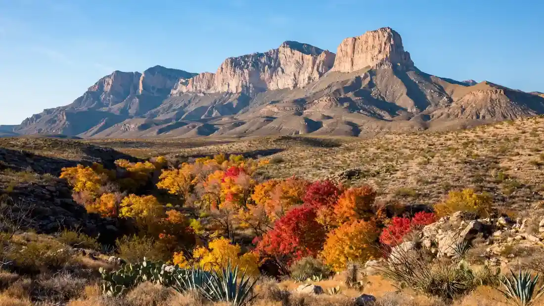
Texas has a mountain problem — most people don’t believe it has any. Then they stand at the base of the Guadalupe escarpment, a limestone wall rising 3,000 feet straight out of the Chihuahuan Desert, and they understand. Guadalupe Mountains National Park is the quietest great hike in the Lone Star State: the highest point in Texas, a canyon that turns scarlet every October, and so few visitors that you can summit the state high point on a weekday and share it with a handful of people. This Guadalupe Mountains National Park guide covers the trails, the fees, the camping, and the fall color timing that make a trip here one of the best-kept secrets in American hiking.
Fair warning: this is a remote park that punishes the unprepared. There are no gas stations, no stores, and no restaurants inside the park. There is barely any cell service. What there is — big empty desert, a fossil reef for a mountain, and trails with room to breathe — is worth every bit of the planning.
Getting There, Fees, and When to Go
The park sits in far west Texas on US 62/180, about two hours east of El Paso and an hour south of Carlsbad, New Mexico. El Paso is the practical airport; Carlsbad is the practical base, with hotels and restaurants about an hour north of the park. There is no lodging inside the park — none — so plan accordingly.
Entry is a modest $10 per person (ages 16 and up) for a seven-day pass, with the $80 America the Beautiful pass accepted. There is no per-vehicle fee; it is charged per adult, and the park’s own annual pass is inexpensive if you will return. McKittrick Canyon, the fall-color heart of the park, has its own gate hours — roughly 8 a.m. to 5 p.m. — so do not plan a sunrise start there.
Late October through mid-November is the prime window, when McKittrick Canyon’s bigtooth maples turn red and gold and the air is cool. Spring is famously windy — gusts strong enough to make the summit dangerous — summer is hot and exposed, and winter is cold and clear with occasional snow up high. Fall is the clear favorite, and right now is exactly when you should be watching the color reports. For more seasonal hiking strategy, see our roundup of the best USA hiking trails for every skill level.
1. Guadalupe Peak Trail: The Roof of Texas
The Guadalupe Peak Trail is the reason most people come: 8.4 miles round trip with about 3,000 feet of elevation gain to the summit at 8,751 feet, the highest point in Texas. Most hikers take six to eight hours. The trail climbs steadily through desert scrub, pines, and finally exposed ridge, with a stainless-steel pyramid marking the summit and views across the desert to El Capitan and the salt flats.
This is a strenuous, fully exposed hike with no water and little shade. Start at first light, carry three to four liters of water per person, and pack layers — the upper ridge can be brutally windy, and conditions change fast. Do not attempt it in high spring winds; rangers will tell you when it is unsafe, and you should listen. The summit register is full of entries from state high-pointers checking off Texas, and joining them is a genuine American hiking milestone. For the safety mindset this kind of exposed summit demands, our guide to staying safe on adventure trips is worth a read.
2. McKittrick Canyon: Texas’s Best Fall Color
McKittrick Canyon is the surprise of the park — a riparian canyon of bigtooth maples, oaks, and walnuts that erupts in red and gold each fall, in the middle of the desert. The trail to Pratt Cabin runs about 4.8 miles round trip; continuing to the Grotto stretches it to about 6.8 miles. Both are moderate, shaded, and gentle — the easy counterpoint to the Peak.
Timing is everything: the color typically peaks in late October to early November, and the canyon’s gate hours mean a civilized start. This is the walk for photographers, for rest days, and for anyone who needs proof that Texas does autumn. Bring the camera and the picnic; there is no better fall walk in the state. After your hike, the quiet of the canyon is the perfect place to review the day’s shots with tips from our travel apps roundup.
3. Devil’s Hall: The Rock Scramble
Devil’s Hall is the park’s fun-house hike: about 3.8 to 4.2 miles round trip up a rocky wash to a natural rock staircase — a slot-like formation of stacked boulders you climb like giant steps. The route involves real scrambling over boulders, which makes it a hit with kids and anyone who likes their trails with a little adventure.
Wear sturdy boots with ankle support; the boulders are unforgiving on weak ankles. The wash can hold water after rain, so check conditions. This is a half-day hike that pairs perfectly with an afternoon drive through the park’s scenic areas.
4. Smith Spring Loop: The Easy Desert Oasis
The Smith Spring Loop is the park’s best easy hike: about 2.3 miles with roughly 500 feet of climbing to a shaded desert spring. It is the walk for arrival day, for grandparents, or for the afternoon after Guadalupe Peak humbled you. The contrast — lush spring in the middle of the desert — is the whole Guadalupe story in miniature.
Start at the Frijole Ranch area, where the historic ranch buildings add a cultural layer to the walk. Early morning or late afternoon light makes the desert glow, and the short distance means you can do it even on a travel day.
5. The Bowl via Bear Canyon: The High-Country Loop
For strong hikers who want the park’s wilderness heart, the Bowl is a high forested basin ringed by the park’s highest peaks, reached via Bear Canyon or the Tejas Trail. These are long, strenuous loop options — eight to twelve miles depending on the route — through Douglas fir and ponderosa forest that feels nothing like the desert below. Fall brings color here too, a week or two before the canyon peaks.
This is backcountry hiking: carry a map, know your bailouts, and treat water sources as unreliable. The reward is the park’s deepest solitude — you may not see another hiker all day. For more high-country solitude at the same intensity, the alpine routes in our guide to the best hikes in Glacier National Park are the natural next step.
Permian Reef: What You’re Actually Climbing
Here is the detail that makes Guadalupe Mountains genuinely special: the entire range is an ancient fossil reef, the exposed Capitan Reef from a Permian sea that covered this land 250 million years ago. The Permian Reef Trail (about 8.4 miles round trip) is built around this story, with interpretive signs explaining the geology as you climb. You are hiking on the skeletons of sea creatures, at 8,000 feet, in Texas. No other American mountain range offers this, and it is worth knowing before you go — it transforms every switchback.
Desert hiking here shares DNA with other great American desert parks. If Guadalupe whets your appetite for more desert miles, our guide to hiking Joshua Tree and the Grand Canyon’s South Kaibab Trail continue the education.
Camping and Backcountry: Sleeping Under Desert Stars
The park’s two developed campgrounds are basic and perfect: Pine Springs, near the main trailheads and visitor center, and the quieter, more remote Dog Canyon on the park’s north side. Both are first-come or reservable depending on the season — check ahead, especially for fall weekends. There are no hookups, no showers, and minimal amenities; there is also some of the darkest sky in Texas. The stargazing alone justifies the trip.
Backcountry camping is allowed with a free permit, and the park’s wilderness campsites are some of the most peaceful in the system. The same desert camping skills apply here as anywhere in the Southwest — water discipline, sun protection, and Leave No Trace — and our beginner camping guide covers the fundamentals. For a deeper desert camping education, our Death Valley camping guide goes further.
What to Pack: The Desert Doesn’t Forgive
The packing list for Guadalupe Mountains is the packing list for all desert hiking, and skimping on it is the most common visitor mistake. Two or more liters of water per person per hike (more for the Peak), electrolytes and salty snacks, a wide-brimmed hat, sunscreen, layers for temperature swings, hiking boots with real ankle support, a paper map or offline navigation, a headlamp, trekking poles for the steep descents, and a first aid kit. There is no cell service in most of the park — download your maps in El Paso or Carlsbad, not at the trailhead.
Pets are limited to campgrounds and paved areas, so leave the dog’s hiking ambitions at home. And the golden rule of this park: check the wind forecast before the Peak, check the gate hours before McKittrick, and check the color reports before the canyon. Three checks, and the park gives you everything it has.
Conclusion: Texas’s Mountain, at Last
Guadalupe Mountains National Park is the answer to a question most travelers never think to ask: where does Texas keep its mountains? The answer is here, in the far west, in a fossil reef turned alpine island, with the highest summit in the state, the best fall color in Texas, and trails empty enough to hear your own boots. Come in fall for the maples, climb the Peak on a calm clear morning, camp under the desert stars, and leave understanding why this park’s small, devoted following considers it one of the great ones. If you are planning a bigger Texas adventure, our USA road trip planner and first-time visitor guide will help you build the full itinerary.