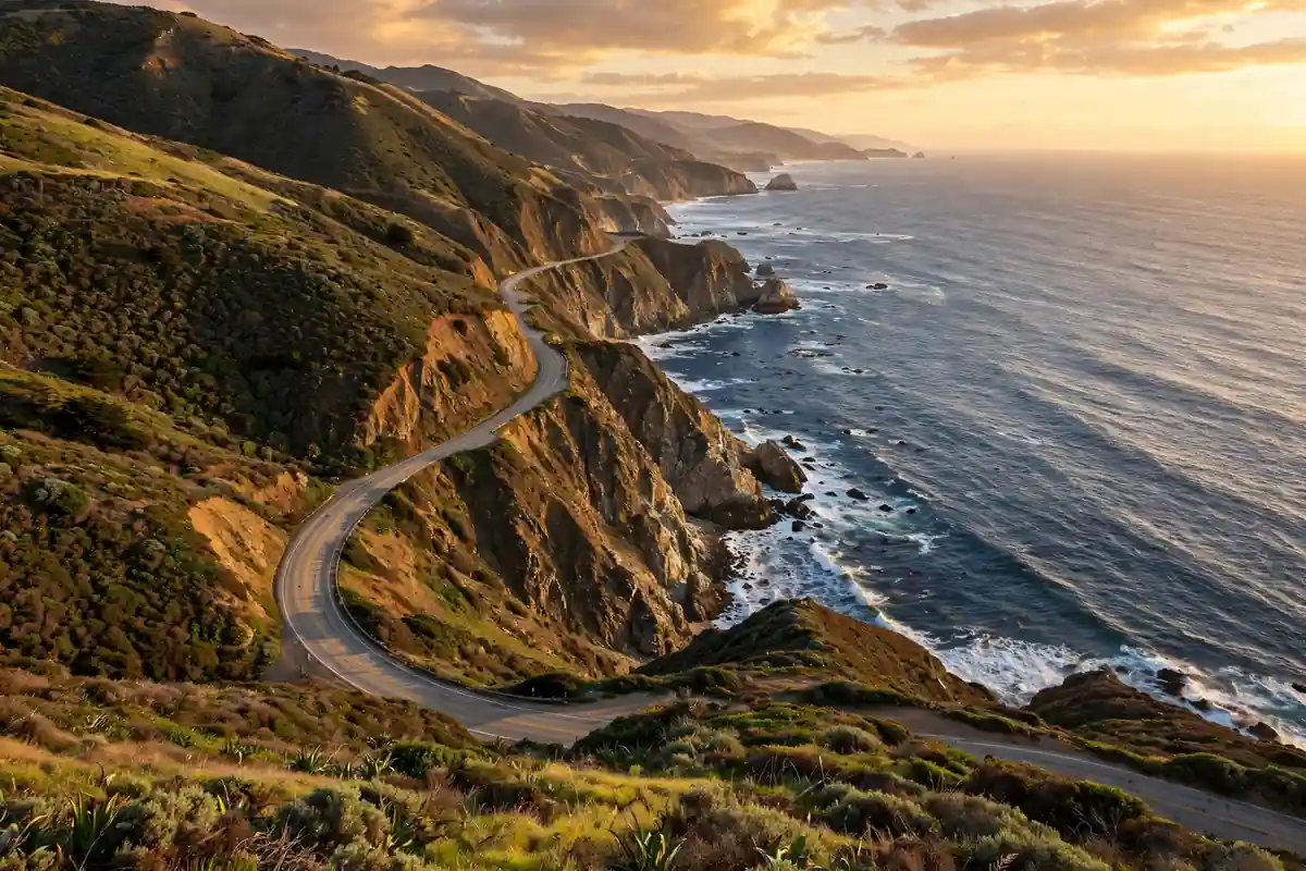
There are road trips, and then there is the Pacific Coast Highway. Highway 1 unfurls along California’s edge for more than 650 miles, clinging to cliffs above a churning ocean, diving through redwood groves, and threading past beach towns that look airlifted from a postcard. It is consistently ranked among the greatest drives on earth — and unlike many bucket-list drives, it genuinely lives up to the hype.
This Pacific Coast Highway itinerary covers the classic San Francisco to Los Angeles run in four days, with the stops that matter, the mileage that keeps it enjoyable, and the hard-won practical tips that separate a dreamy coastal cruise from a stressful slog behind an RV in the fog. Whether you have a long weekend or a full week, this plan shows you how to do it right.
Pacific Coast Highway Itinerary at a Glance
- Day 1: San Francisco → Monterey & Carmel (120 miles, 2.5 hours driving)
- Day 2: Monterey → Big Sur (70 miles, 3 hours with stops)
- Day 3: Big Sur → Santa Barbara (150 miles, 4 hours driving)
- Day 4: Santa Barbara → Los Angeles (95 miles, 2 hours driving)
Total: about 435 miles of the most scenic driving in America. If you have five or six days, add a second night in Big Sur or extend south to San Diego. For even more route inspiration, our ultimate USA road trip planner covers 20 epic routes across the country.
Which Direction: North to South or South to North?
Drive south — San Francisco toward Los Angeles. This is the single most important decision of your trip. Heading south puts you on the ocean side of the road, which means the turnouts and viewpoints are on your right, with no oncoming lane between you and the cliff-edge views. Heading north, you are stuck on the inland side, craning across traffic.
There is a second reason: the light. Afternoon sun illuminates the coastline when you are driving south, turning the ocean deep blue and the cliffs gold. Morning fog — the famous marine layer — usually burns off by midday, so plan your Big Sur stretch for the afternoon hours. Drivers used to left-side driving or first-time visitors to the country should also skim our USA travel guide for first-time visitors before getting behind the wheel.
Day 1: San Francisco to Monterey and Carmel (120 Miles)
Pick up your rental car in San Francisco and point it south. The first stretch is the least dramatic — Highway 1 hugs the coast past Pacifica and Half Moon Bay, pretty but not yet spectacular. Your first real stop is Santa Cruz, about 75 miles in, for the vintage beach boardwalk and a walk on the wharf.
Monterey and the 17-Mile Drive
By afternoon you reach Monterey. Walk Cannery Row, visit the world-class Monterey Bay Aquarium if you have two hours to spare, then drive the 17-Mile Drive through Pebble Beach — a tolled scenic loop past the Lone Cypress and dramatic oceanfront golf courses. It costs a few dollars per car and takes about an hour with stops.
End the day in Carmel-by-the-Sea, ten minutes south — a storybook village of cottages, galleries, and white-sand Carmel Beach, consistently rated one of America’s prettiest small towns. Have dinner on Ocean Avenue and watch the sun drop into the Pacific. If you flew in for this trip, our guide to find cheap flights can save you serious money on the airfare.
Day 2: Monterey to Big Sur (70 Miles of Pure Magic)
This is the day the whole trip is about. The 70 miles from Carmel to Big Sur contain the most photographed stretch of coastline in America, and you should budget a full day for it. Fill your tank in Carmel — gas in Big Sur is scarce and shockingly expensive — and hit the road by 9 a.m.
The essential Big Sur stops
- Point Lobos State Natural Reserve (just south of Carmel) — sea lions, cypress groves, and turquoise coves on easy loop trails. Go early; the small lots fill by 10 a.m.
- Bixby Creek Bridge — the iconic 1932 concrete arch bridge. Park at the turnout on the north side and walk back for the classic photo. Do not stop on the bridge itself.
- Pfeiffer Beach — a detour down an unmarked road (Sycamore Canyon Road) to a beach with purple sand and a famous rock arch. The turn is easy to miss; watch for the small sign.
- McWay Falls (Julia Pfeiffer Burns State Park) — an 80-foot waterfall dropping onto a pristine beach. The overlook is a five-minute walk from the parking area, and it is the single most photographed spot on the highway.
- Nepenthe — the legendary cliffside restaurant. Even if you only stop for a coffee on the terrace, the view over the coastline is unforgettable.
Spend the night in Big Sur — at a lodge, a cabin, or one of the campgrounds tucked into the redwoods. Waking up above the fog line with the ocean below you is worth every penny. Big Sur at golden hour is also a photographer’s dream; our travel photography tips will help you nail those cliffside shots.
A note on Big Sur road closures
Big Sur’s cliffs are geologically restless, and landslides periodically close sections of Highway 1 — sometimes for months. Before your trip, check Caltrans QuickMap for current conditions, and have a backup plan: if the road is closed through Big Sur, the inland detour via Highway 101 adds hours but keeps the trip alive. Never trust a GPS blindly here; confirm the road is open the morning you drive it. The same check-before-you-go habit applies to any big drive — it is a core part of our travel safety tips for road trips.
Day 3: Big Sur to Santa Barbara (150 Miles)
Leave Big Sur after a slow morning — the southern stretch of the highway is wilder and emptier, and it deserves unhurried driving. About 30 miles south, stop at Ragged Point, the dramatic headland that marks the end of the cliff-hugging section, for one last look back up the coast.
Hearst Castle and the elephant seals
Next comes San Simeon, home of Hearst Castle — William Randolph Hearst’s hilltop estate, now a state park offering guided tours of its pools, art collections, and absurdly grand rooms. Book tour tickets online in advance; the basic Grand Rooms tour takes about an hour and is the best introduction. Five minutes north, the Piedras Blancas elephant seal rookery lets you watch hundreds of massive seals lounging on the beach from a boardwalk — free, and genuinely fascinating.
The highway then straightens out through Morro Bay (spot the volcanic Morro Rock) and the Danish village of Solvang, a worthwhile 20-minute detour for pastries and windmills. By late afternoon you roll into Santa Barbara, the “American Riviera” — stroll State Street, walk the waterfront, and have dinner with your toes near the sand. It is the most relaxing overnight of the trip, and a reminder that great drives pair beautifully with great towns, whether you are road-tripping Iceland’s Ring Road or cruising California.
Day 4: Santa Barbara to Los Angeles (95 Miles)
The final leg is short, which leaves the morning free for Santa Barbara’s Funk Zone or a kayak trip to the Channel Islands (book ahead — it is one of the adventure activities in the USA most travelers overlook). Then follow Highway 1 south through Carpinteria and Ventura into Malibu.
Malibu’s 21 miles of coastline deliver a greatest-hits finale: Zuma Beach, El Matador State Beach with its sea stacks and caves (go at low tide), and the Malibu Pier. From there, the highway becomes Santa Monica’s Pacific Coast Highway proper — end your drive at the Santa Monica Pier, where Route 66 meets the sea. Watch the sunset from the pier, and you have completed one of the world’s great road trips.
Optional extension: add San Diego
Got two extra days? Keep going south past Los Angeles to San Diego — another 120 miles through Laguna Beach, Dana Point, and Carlsbad. The full San Francisco to San Diego run is the complete Pacific Coast Highway experience, and San Diego’s beaches and Balboa Park make a perfect trip finale.
Where to Stay Along the Pacific Coast Highway
Book Big Sur lodging months ahead — it is the one stretch where demand wildly exceeds supply. Practical picks by stop:
- Monterey/Carmel: the most options and the best value; Carmel’s inns book out on summer weekends
- Big Sur: lodges and cabins are pricey but unforgettable; campgrounds like Pfeiffer Big Sur State Park are the budget play — reserve the moment bookings open
- Cambria/San Simeon: the smart budget overnight if Big Sur is full or over budget
- Santa Barbara: beachfront hotels on Cabrillo Boulevard or boutique inns downtown
Mixing one splurge night (Big Sur) with budget nights elsewhere keeps the trip affordable. Our backpacking on a budget guide has lodging and food strategies that translate directly to road-trip savings.
What to Pack for the Drive
- Layers — coastal California swings 30 degrees between foggy morning and sunny afternoon
- Offline maps — download the route; cell service vanishes through Big Sur. The best travel apps for 2026 include excellent offline navigation options
- Cooler and snacks — services are thin between Cambria and Big Sur
- Quarters and a card — some state park lots still use old-school pay stations
- Motion-sickness remedies — the Big Sur curves are relentless; nervous passengers should sit up front
Best Time to Drive the Pacific Coast Highway
Fall (September–October) is the sweet spot: the marine layer retreats, skies clear, crowds thin, and the light is spectacular. Spring (April–May) brings wildflowers to the Big Sur hillsides and waterfalls at their fullest. Summer is warmest but foggiest — the coast can sit under grey marine layer for days while inland bakes. Winter is dramatic and empty, with storm-watching appeal, but it is also landslide season, so check road conditions obsessively. Year-round, weekdays beat weekends for both traffic and lodging prices.
Coming in winter? Pair the drive with a detour to our best places to see snow in California for a coast-and-mountains combo trip.
Conclusion: Why This Drive Belongs on Your List
The Pacific Coast Highway is not just a road — it is a four-day highlight reel of everything California does best. Redwood groves and sea cliffs, elephant seals and Danish bakeries, fog-shrouded bridges and sun-drenched beaches, all strung along one ribbon of asphalt. Drive it south, take your time through Big Sur, and let the turnouts dictate your schedule.
Four days is the perfect minimum: enough to savor each section without rushing, short enough to fit into a long weekend plus a day or two. Add San Diego if you can, linger in Big Sur if you must, but whatever you do — check the road conditions, fill the tank, and go. Some drives you remember. This one you will measure every future road trip against.